Wednesday, May 18, 2016

A Trip to Vancouver and Back

It all started because Elaine found that plane tickets to Europe cost about half as much if the embarkation point was Vancouver BC. So I volunteered to drive her and a friend the 7 hours through Seattle and up to Vancouver for the drop off. We planned poorly and hit rush hour on Seattle's northbound 405. We took the express lanes so it wasn't too bad. The whole trip over was fairly uneventful. 

I found a nice 1920s bungalow Bed & Breakfast (Clair's) in a small Vancouver suburb named Ladner. The decor was a bit colorful, but we had a wonderfully pleasant host. 

Here are my digs. 

Cosy twins in the next room with the roof eaves right overhead always makes for the most comfy sleep. Everyone slept well. 

I got the kids to the airport with plenty of time and then began my somewhat leisurely drive home. 

Two things I want to do on this trip: 1) see the air museum in Concrete WA, and 2) drive the North Cascades highway. 

I didn't write it up as an adventure, but last year Mike and I flew over to the Arlington air show. 

Here we are sitting under the wing of the Monocoupe amongst the completely fried grass that year. 
Anyhow, while there we met Drew, a pilot/mechanic from the North Cascades Vintage Aircraft Museum. I couldn't help but notice the tattoo on his forearm that looked just like a sticker on the door of my plane portraying the logo of the National Air Races of the 1930s:

Here's a facsimile of the tattoo. He just had the winged head. You can barely make out the sticker on the door of the plane in the above image. 
Drew's museum brought down at least five planes from their collection, including a Mooney Mite, which is why I started talking with Drew in the first place. I have a Mite project and I'd never seen one all together in person before. I had a lot of questions. 
This museum is never before heard of is why I wanted to stop in Concrete. It's a pretty good collection, but way off the beaten path. 

The museum was closed this day, but the  airport gate and a couple of the hangars were open, so wandered in an used my Monocoupe card to get a private tour of the entire collection. Ever since I bought this plane, I get private tours from every aviation museum I come upon. I don't even have to have the airplane with me. And they've usually heard of me. It's a small circle of people that know and appreciate planes to this level of detail. 

On with the tour. The museum has 6 hangars that house about 8 planes each for about 50 planes, most falling in the pre-to-post war period. Oh yes, the thing to notice in the above pic is not the cub in front, but Douglas cockpit up in the peak of the hangar. I can't tell if it's a DC-3 or a DC-6 from here, but I'll guess 3. 

The first plane I noticed amongst all the fine planes here was the Baby Lakes. It was designed as a mini Great Lakes, and from all I've heard, it lives up to that name very well, except for a reputation for short-coupled quickness worse than a Pitts. The only way to land it is with a locking tail wheel. I, of course, liked it because it was tiny it was, making it the most affordable and achievable plane that a young man could ever dream of. Look at it! It's barely 5 feet tall. 450# empty. Ah the hours I wasted on that dream (and the Powell Racer -- look it up )

Next is the museum's newly acquired Beech Staggerwing. The story of the flight from Pennsylvania is found here: http://vintageaircraftmuseum.org/. It's an interesting read, much like my own blog of last summer's cross-country odyssey in the Monocoupe. 

But here is the real reason I wanted to visit this museum. "The Spirit of Dynamite" is a 165 hp Warner Scarab powered Clipwing Monocoupe. And it is beautiful. You know, I was so busy looking at all the planes that I forgot to take a moment to look inside this one to see if it has the offset right stick as mine does. 

Wait a minute, I think I recall that I did, and it does. 
Well, that was an awesome start to a road trip. Can't wait to go back there. In fact, this trip turned into a series of visits to airports I've never seen before. It's kind of like that scene in the Patton movie where George C Scott says "I can smell a battlefield."  I am the same way with airports. All told, I stopped at six airports in this trip. Few pictures, though. 

On with the trip. Here is the Diablo Dam, of Seattle City Light. This is at the west foot of the North Cascades pass, the low end. Something like 2000 ft elevation here. 

Interesting pass from a pilot's perspective. The east end still has snow in the second week of May. Its 5300 ft at ground level, and I wouldn't fly it below 6000 ft, but the peaks immediately surrounding are in the 8500 ft range. And it's quite a long pass, around 40 miles. As passes go, Snoqualmie is much lower, shorter, and amenable to engine failure. And if you're really a chicken, just fly the Gorge. The highest spot on the way to the Gorge is just east of Colfax. 

And I'd never been to Winthrop (the entire Methow Valley for that matter) before, and it turned out to be THE perfect week for doing so. The locust trees in Winthrop were in full bloom. And I've never seen thicker or smelled more fragrant locust blossoms. Everywhere by the river. 
The above pic shows my seat and beer (a wonderful milky stout) for lunch at "The Schoolhouse" brewpub. It was actually hard to find the place. I saw the sign by a skinny door/building that I walked right by, wondering "where is this brewpub?" Turns out the building is sort of triangular, narrow as the door at the front and widening as it backs to the river. Plus the Main Street entrance is 10 ft above the river bank, so the back patio has two levels, the lower, larger one being right on the river bank with a beautiful natural canopy of locust blossoms. 

And the blossoms, here hanging right over my head, imparted a lovely scent reminiscent of orange blossom water, which was exceptionally complimentary to my meal. Well, that was a lucky find. 
It was so nice that I bought a tshirt. 

I poked the nose of the car into the Winthrop and Twist airports, but saw nothing of interest until the Pateros airport where I found a passel of Sikorsky CH-34 (Choctaws). Not sure what they're used for. Didn't stop to ask. 

Lots of them. 

But the real find at the Pateros airport was the future tour bus of my new band: "Electric Love Bucket." I should have found out who owned it, but, again, I didn't stop to ask. 

All this airport and scenery touring ended when dusk (and the wandering deer) caught up to me at Grand Coulee, so I got a hotel for the night. 

Tomorrow: Steamboat Rock. 


Sunday, March 27, 2016

The Great Dry Falls

Awhile ago I decided to take a day flight around eastern Washington to see the Great Dry Falls. Long story, but what are we here for if not to tell and read a long story. 

10,000 years ago a glacier repeatedly blocked the mouth of the Clark Fork River where in enters Pend Orielle Lake in northern Idaho. This ice dam caused a lake to form in Missoula about a a thousand feet deep. Glacial Lake Missoula. About every 50 years the water would get deep enough to float the ice dam, breaking it up and the entire lake would empty through eastern Washington and the Columbia River in four to ten days. This occurred at least 50 times, and probably more like 75. 

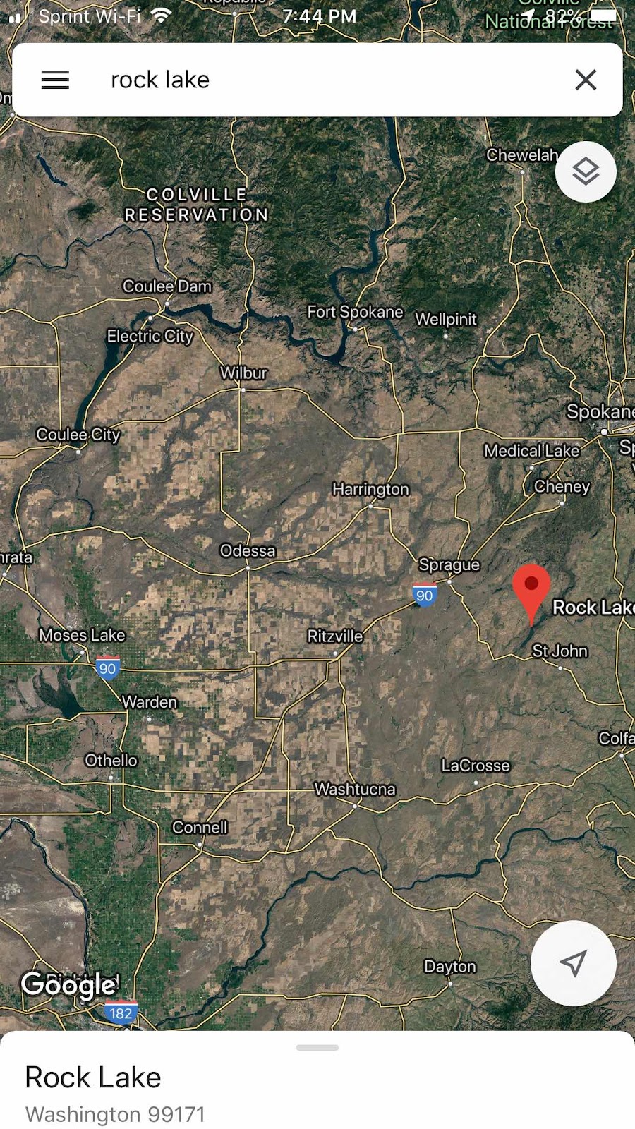
A look at eastern Washington on google maps easily shows where the water coursed. 


All the land that is brown is where the floods repeatedly ran. 

All this info is detailed in the book “Cataclysms on the Columbia”, which should be required reading for anyone traversing eastern Washington. 


So I headed WNW from pullman for about an hour to reach Steamboat Rock, at the head of Banks Lake, which was a higher dry coulee below (in river speak) but above (in altitude) Grand Coulee Dam. The dam uses Banks Lake as a reservoir, pumping water up into it for use as part of the Columbia Basin Project or for later electrical generation. 

Steamboat Rock is at least four times larger than an aircraft carrier, and a couple hundred feet above the lake. It’s quite fun to hike around on. It is a rock in the middle of a coulee that withstood the floods. 


This pic gives a better idea of what a coulee is. Eastern Washington has layer upon layer of basalt, deposited by volcanos on either side. Rainier, Adams, on the west, the great Yellowstone on the east. The floods came through and tore up large longitudinal swaths through ten or twenty layers of basalt, each about 10 feet deep, which end up as u-shaped valleys of up to 200 ft depth, an drywall but 10 days very 50 years. 

Note the top of the plateau which has little soil. Where ever the water ran, it stripped the rich soil, most of which ended up in the Willamette Valley - read the book for details on Lakes Wallulla, Condon, and Willamette, which only existed for 50 or so days every 50 years. 

Yes, the soil was a couple hundred feet deep in eastern Washington, a very rich loam created by eons of volcanic ash deposits. It was all as rich as the farming area called “The Palouse”, on the border of eastern Washington and north Idaho, but most was washed away by the floods. 


Back to the story. I flew south down Banks Lake, at the end of which is the Great Dry Falls. Here is the approach to the falls. Note that I am 1000 ft up at this point, and that is a road crossing the dam at the end of Banks lake, with tiny little cars on it. The picture cannot capture the entire field of view, which runs from 45 to my left to the same angle on the right. 

This waterfall was three times the size of Niagara. 


Same place, looking to the left. The falls were in the trench. 


And to the right. 


Half of the fall is a trench to the left (east) that can only be seen from the air, or by boating the lake that sits at the foot of the 10 story falls. I have yet to kayak that, but it’s on my todo list. 


The western half of the falls have eroded back up to the north and cane be viewed from the overlook on the highway on the west side of the pit. You can barely see the visitors center on the far side of the Dry Falls. 


Staircase Rapids

Here's the next installment on my "Hiking the Scablands" series.  Unfortunately, there is very little hiking to be had on this entry.  Maybe 10 ft.

But there is interesting Missoula Floods geology, so I'm posting it. Today's lesson takes place about 6 miles NE of Washtucna, on Hasse Rd. 

This is a blowup of the small square in the first image. Missoula floods, read up in my previous posts, or elsewhere on the web.  In this case, the flood was 2 1/2 miles wide down a series of 20 ft falls a mile or so apart -- at least four steps.  That's right -- a large waterfall in four twenty-foot drops, 2 1/2 miles wide and 4 miles long.

Above I've outlined two of the cliffs (the cliffs are below my line, so I wouldn't obliterate the cliffs on the image).  The arrows show the flow of water.  The X is were I stood when taking the below pictures.  Note the piece of the Palouse still standing in the middle of the second row of falls, splitting the flow.

This is looking to the west (sorry, into the setting sun).  Here is a dry fall 2 1/2 miles long and 20 foot deep.

Looking down flow, to the SW, you can see the one remaining Palouse hill splitting the flow.

And a zoom in the same general direction barely shows the next drop a mile or so downstream.

This land is now all fenced off and used for cattle, but you used to could hike the first ridge from the west end.  Sorry, no hiking today.  I mean to fly down these rapids at low level this summer.  I don't have a go-pro camera, and wouldn't expect it to give the same effect as being in the airplane with all of the peripheral sights necessary to get the full effect anyway.

Next entry: I do have aircraft photos of the Great Dry Falls from an airplane last summer, and steamboat rock.  It's on my todo list to hike what I can of it, and that will be a mighty bit of hiking, assuming it's all accessible.


Devil's Canyon

Devil's canyon is a geological feature caused by the Missoula Floods around 10,000 years ago.

To better understand these images, take a look at the satellite image below:
This is a snapshot of most of the Columbia Basin in Eastern Washington.  Most of the brown areas in the above image are where soil was scoured away in the floods.  You should really look up more details on the Missoula Floods because it really is an amazing story, but in a nutshell:

During the last ice age, an arm of the ice sheet blocked the outflow of the Clark Fork River into the eastern end of what is now Lake Pend Orielle.  This ice dam occurred about once ever 50 years, at least 42 times.  So for 50 years, water would back up behind this dam in what is now known as glacial lake Missoula (1000 ft deep where Missoula now is).  When the water got deep enough, it lifted the ice dame and rushed out in an estimated 4 to 10 days, scouring Eastern Washington, creating temporary lakes there, in Eastern Oregon, and the Willamette Valley for weeks afterward, and greatly altering the landscape of Eastern Washington.

The square in the above image is blown up to show more detail of the small detail I'm referring to.

Large swaths of the Palouse soil were swept away, and in some places many layers of basalt from much older lava flows were torn up in stretches.  These U- and V-shaped valleys are called "coulees" and are sometimes hundreds of feet deep.  They are quite impressive to stand in.  Some good examples are Banks Lake, Rock Lake, and the Grand Coulee, which is now a reservoir created by the Grand Coulee Dam.  Devil's Canyon is interesting because it begins at the Elbow of Washtucna Coulee.  I'm not an expert geologist, but the summary seems to be that water flowing down Washtucna Coulee to the SW from Washtucna met backwater created by the Walulla Gap flowing east from what is now Connell and overtopped the south edge of the coulee and begat Devil's Canyon, which is a relatively small feature in all of the Eastern Washington scablands.

It's interesting because it's a deep trench that starts near the top of a hill and has no creek flowing in it.  And standing in it is like standing in a sewer with no top and no flow.  You know a huge flow caused it, and the thought of a flow happening make standing there somewhat unnerving.  I supposed that's why it's called Devil's Canyon.  There is a railroad and a road in the canyon, the railroad long since abandoned, and now it's part of the Columbia Plateau Trail, which, when completed, will be a rails-to-trails bike trail all the way from Spokane to the Tri-Cities.  And the original RR tunneled through the basalt layers, about a half mile long, at the top.

Above is a picture of the particulars near the top.  The top arrow is the beginning of the train tunnel, and it's only about 200 yards from magnificent downtown Kahlotus.  The bottom arrow is the other end of the tunnel at the top of Devil's Canyon.  Some of the pictures I took looking up and down the canyon were taken from the edge of a basalt cliff marked by the X.

One of the reasons this place is unusual is the approach to the RR tunnel, which is a trench dug out at the beginning of it.  Very confining.

About 50 yards from the tunnel I was met by a blast of air conditioner-cold air from a cold wind blowing up the canyon on the other side of the tunnel.  Also a bit unnerving.

It's only a half mile.  What could happen?  It's like staring down the barrel of a loaded gun.

Ok, fine, enough of this.  Let's get to the other side.  Since the RR tunnel stays mostly level, and the road climbs to this point, the tunnel is well below the plateau on the canyon side, but since the floods created a sort-of pointed head to the canyon by what I can only assume would be an awesome waterfall, that's where the tunnel comes out -- at the base of that imagined waterfall.

The rail bed from above the tunnel opening on the canyon side. The road is on the bluff above to the left.

You can begin to see the crazy V-shaped trench this trail lies in.

To get a better look, I hiked on the side of the canyon, about 100 feet up.  It's not as treacherous as the trial in Hell's Canyon (in spots), but it is narrow and side-hill.

And there are cliffs. The above pic is looking up canyon from the X.

Here you can see all the way down the canyon, at the end of which is Lower Monumental Dam on the Snake River.  The road is on the left and you can see that it meets the level of the RR about halfway dow the canyon.  From there the road stays in the bottom and the RR climbs the wall on the right, until it is about 200 ft above the river when it meets the Snake River Canyon.  From there the trail gets really interesting.  The railroad stayed very high because there is only 45 deg bank into the river below.  So the RR alternates on trestles and tunnels through the Snake River Breaks most of the way down to the Tri-Cities.  Funding has not yet been forthcoming to complete this part of the trail, so the trestles are clearly fenced off, but the section from Washtucna to Windust Park (3 miles below the Lower Monumental Dam) would make for an excellent trail marathon.

Upcoming posts:
Staircase Rapids, NE of Washtucna.
The Great Dry Falls (3 times the size of Niagara, with no water falling)


Tuesday, March 1, 2016

Towell Falls

Tuesday, 23 Feb, 2016

The big falls at Towell Falls. 

One day last summer I was buzzing around the Channeled Scablands of Eastern Washington with my friend, Leah and we came across a waterfall I'd never seen before. 

This is Leah. 

I actually spend a lot of time in the air over the scablands and have seen most of them that are near the Palouse, but I hadn't really spent the time to understand what I was seeing. Well, those falls kinda got under my skin. Sorry I don't have a picture of them from the air, but seeing any waterfall in that part of the dessert at that time of year was unusual. 

I placed that thought on the back burner and in the meantime I'm wanting to take up hiking as a hobby. So I went down to Hyperspud sports and got a couple books on hiking Idaho. Unfortunately, most of the Idaho trails I want to do (Seven Devils, Selway River, etc) say May or June to November. Bummer. I've been building up my walking mileage around town, often getting 10 miles a day, and I don't want to wait til June. So then I found this book at Hyperspud:

With this book I found a treasure trove of trails that are near their best in February and March, and I also found Towell Falls on Rock Creek. For that was the waterfall I had seen from the air, and it turns out to be on BLM land as part of the Escure Ranch Recreation Area, Hike #8. 

Here's how to get there from Moscow. Just two hours and only the last half hour is on dirt roads. You will notice that the closest thing to this place is Benge, which is smack dab in the middle of nowhere. If you ever want to see the end of the world, go to Benge. 

This is (or was) the bank in Winona, a next to non-existent town right at the end of the Palouse and the beginning of the scablands. It is one of four defunct downtown buildings. 

You turn off pavement and onto this dirt road shortly after Winona, it's actually a beatiful drive and the road, though gravel, is actually quite good. It winds beautifully through basalt mesas, basically the only way the road could get through here. 

Then you turn onto the entry road for the Escure Ranch, and there is this, more suited to a 4wd that the Mazda 3 I was driving. Lots of water holes in the road, often all the way across. But I made it ok. 

Here's the old cattle/sheep ranch as viewed from the parking area. There are two published hiking trails here. One is the Towell Falls out-and-back that I walked this day, and the other is Turtle Lake Loop, which I will have to try on another day. I don't have my mileage up that far yet. 

Here's the trail. You can see that it follows Rock Creek where it can, but then goes up over the back of a large basalt outcrop because the creek runs right up against the basalt cliff, leaving no room for a trail. 

Here is the start of the trail looking south. It's very reminiscent of Monument Valley, but smaller in scale, and much closer. I've never been to Monument Valley, but I can't imagine it being better than this, having all this terrain right up close, towering over me. I loved it!

At that early morning and season, I couldn't really see the first cliff until I got close enough for the sun to go behind it. Kind of a sudden shock to see this 150 ft cliff right next to me all of a sudden. 

Same cliff less than a half mile beyond. The previous pic is under the shadow on the left side of the left one. My grin can be interpreted as "It's Tuesday morning and I'm not in a cubicle!" or "Can you believe this? I'm finally getting out and doing something besides house projects!"

It's an easy hike on a 4wd trail. Only 3 miles. 

The monuments across on the west side of the valley. 

Climbing over the back of the basalt cliff which the creek hugs too tightly on the right. There are trails over the top of this rock, but I stayed on the path, which goes through a bumpy little valley right under 60 ft cliffs on the right ahead. 

The big falls, from a half mile away. 

There are actually 3 falls at Towell Falls that surround a small island. I only saw the big falls from the air, but a google recon of the area made me think to bring some rubber boots. I can't ford the entirety of Rock Creek -- too deep and fast -- but I might could wade across the north channel to the island to get a close look at the big falls. 

Anyhow. There are two smaller, taller waterfalls into the U-shaped hole that is the creek in the upper half of the above picture. One is at the base of the U, and the other is on the lower side of the U. The big fall is clearly seen in the Google satalite image on the south side of the island. 

Here is the upper falls on the small channel on the north side of the island. The falls are about 12 ft high and this seems like an excellent swimming hole, except it might be hard to climb out of. And here is a video:  http://youtu.be/wDieJvsZUsA

I sat here, above the upper falls, eating my lunch of a slab of ham sandwich and Oreos and contemplating the universe (note to self: remember the box of wine next time). 

Even on the small channel, it took a bit of courage and searching to find a place to ford the stream that would not overtop my rubber boots. 

I finally got across without dunking my phone/camera. Here is the smaller falls on the side of the upper channel. 

An easy wade of that stream gets you to the other side of the island and the big falls: http://youtu.be/ZhOMn2fvwk0

Just happy to be here. 

An elk/deer hang out on the island near the big falls. Evidently, this tree is tasty. 

After about an hour hanging around the falls I headed back. The views are better with the sun now behind me. 

Rock Creek. Which flows out of Rock Lake. I'll tell you a story about that another time. 

Massive basalt cliffs carved out by the ice age Missoula floods. Look 'em up. That's how all these scablands got here. 

The ranch house, with windows and doors now protected by metal screens. 

The pre-history of the place. Can you read that?

Escure Ranch history, part II.