Saturday, July 16, 2022
Saturday, January 29, 2022
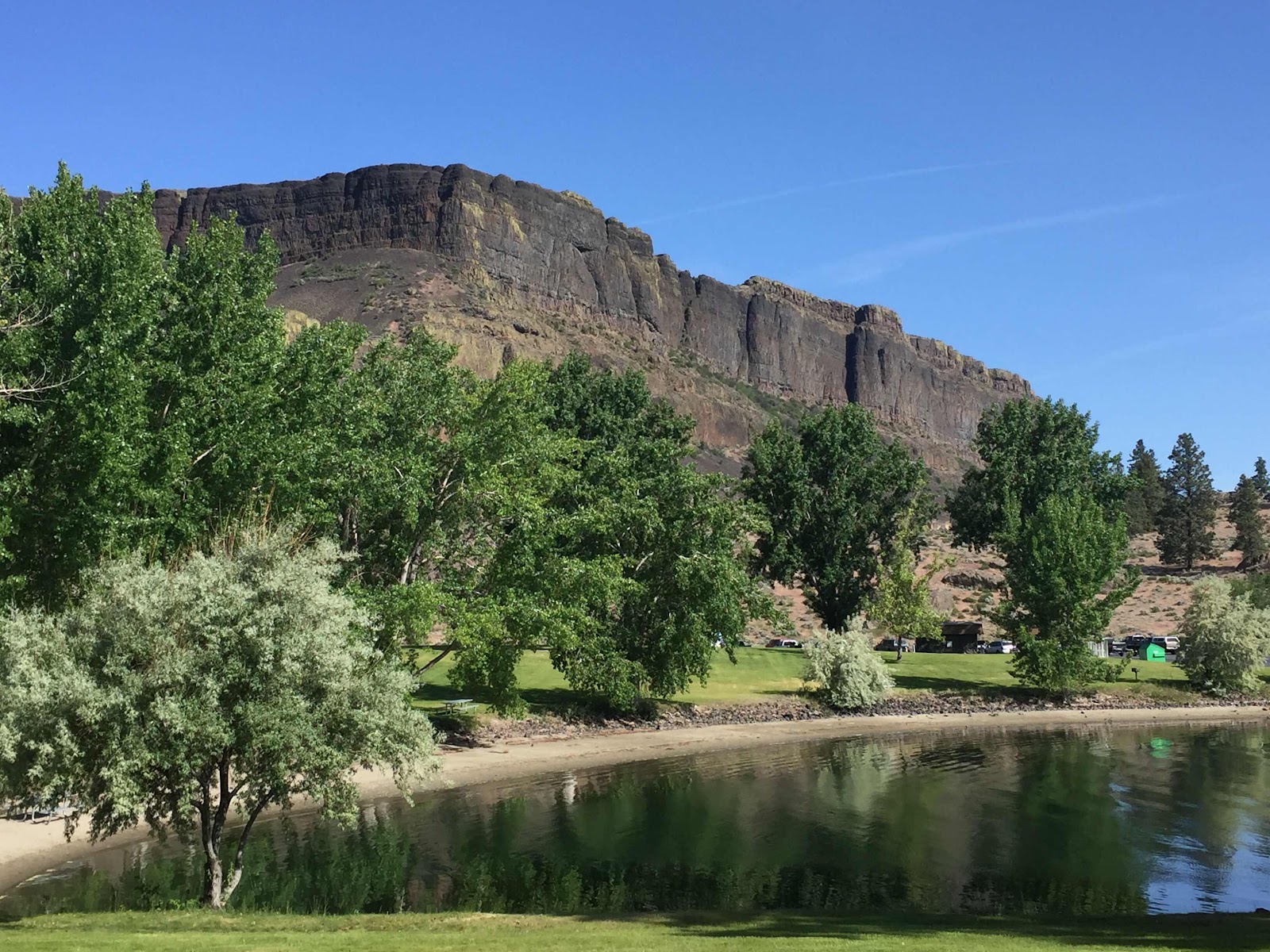
Hiking Red Bird Canyon
I've been meaning to hike the entirety of Red Bird Canyon for a year now. Turns out to be a bit of a challenge. 5 miles one way, from the top at 3300ft to 750ft at the bottom. Plus, its so nice down on the river that you should really spend a significant amount of time down there. I merely sat for 10 minutes on a rock and had the standard European hiking fare of wine and cheese, but you should really bring a nicer spread and take a couple hours.
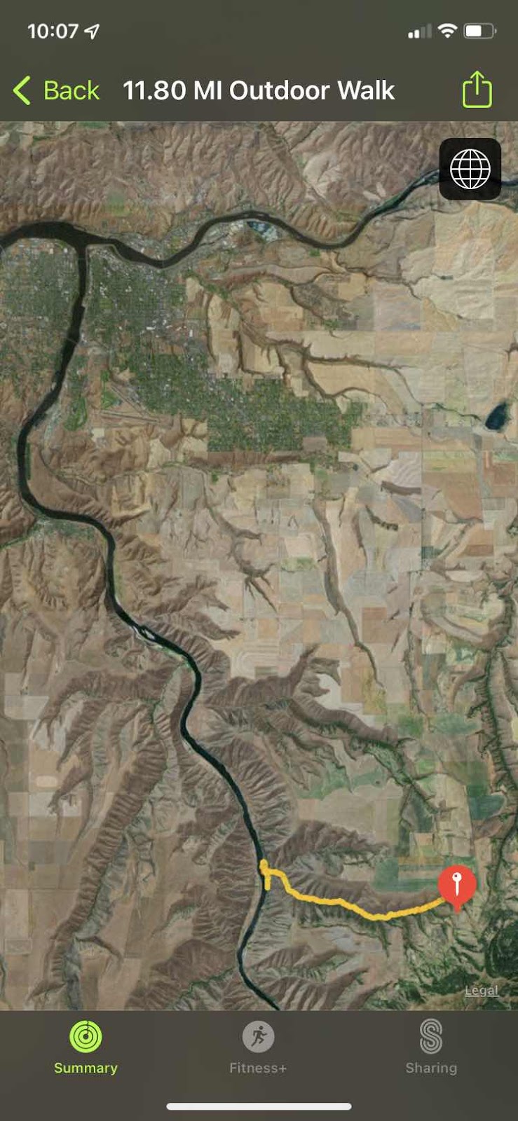
Red Bird is 20 miles or so south of Lewiston.

I would not normally consider this "Hell's Canyon", but I think its easiest to judge that anything south of Hell's Gate Rock (It really doesn't have a name, but it should) to be part of Hells Canyon. That includes Asotin, by this definition.

BTW, this is Hells Gate Rock. You drive right under it (it's at least 10 stories high) as you drive from Clarkston to Asotin. Hells Canyon is legendary from the time of the earliest explorers of what became the western United States. It is the deepest canyon in the US, and the land that surrounds it rises 7000 to 8000 feet above the river at points. The canyon walls descend at a typical angle of 45 degrees and a many points plunge straight down into the river such that no land navigation can occur on this river without hiking up sometimes as much as a mile. This is why it was named Hells Canyon. To this day there are no roads in at least 50 miles of the canyon, (that's a bad guess, I'd say it's more like 150 miles).
The only way to get in to most of the canyon is to either jet boat in or hike.

Me near the top. Still fresh. Got all my layers on still because it started out 28 degrees with a biting SW wind.

The trail is a double track. Looking down canyon.

The trail is a double track. Looking down canyon.
You start on top of the prairie and as you go down, you can see the tops, but sometimes the canyon itself obscures view of the top.

Evidence of human habitation about 3 miles down.

Basalt everywhere, often columnar.

Last straightaway before the bottom, about 1 mile up from the river. I took this picture because of the nearly vertical game trail that goes straight up just left of center. I need to climb that trail some day.

Last straightaway before the bottom, about 1 mile up from the river. I took this picture because of the nearly vertical game trail that goes straight up just left of center. I need to climb that trail some day.
Very rarely there would be a nice "meadow" that actually received sunshine. I hike this at the end of January, so the sun was low enough to never hit large swaths of the canyon. Lots of snow lying about.

Lunch at the river. Looking south to the sun. Grand Ronde River that way.


Lunch at the river. Looking south to the sun. Grand Ronde River that way.
The north end of the effluvium from the canyon has a nice soft sandy beach. A much easier way to get here would be via jet boat from Lewiston. I'll explain later what a jet boat is.
Ok. It’s later. Here’s a short vid to give you an idea of how big the Snake River breaks are.
Oh, here’s a jet boat. It’s noisy, with a big engine, but you don’t really have an idea what they can do til you see them go thru rapids.
This is what they can do.
Plus, the jet impeller is above the hull of the boat, so they can run in almost now water at all.
Foundation of a pioneer house at the mouth of Red Bird creek. The only road here is on the other side of the river.
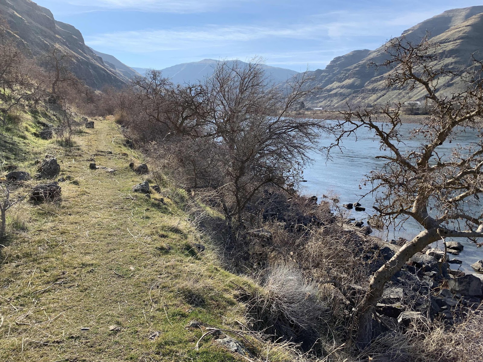
Once on the river, you can follow the "Upriver Trail" south, I'd say at least 30 miles. It seems like it used to be a hand-made wagon road, but rocks falling from the hills and trees that are now at least 50 years old have made this thoroughfare foot traffic (and maybe horses) only.
Looking north, over my shoulder you can see the homes and the road on the west side of the Snake River.

Myth of the mountain man. 28 degrees with a wind chill to 20, a box of wine, a 2600 vertical climb, and only two thin layers of cotton. Plenty warm for the Idaho hiker.
Thursday, January 9, 2020
Monday, June 24, 2019


Friday, April 14, 2017
Flight Around the Blues
I have 7 hours of flight this year, which is a lot for me at this season. There have barely been 5 flying days. The weather has absolutely stunk.
Thank Mike
Mike is searching for a new plane because the one he was leasing was crushed when the hangar collapsed. I guess there been a lot of that going around this winter in Parma.
He thought he found a 150 hp Supercub in Lacrosse WA, so he arranged to have it ferried down to Boise for the pre-buy inspection with his mechanic. "Rain of Biblical Proportions" in Parma caused him to not be able to farm on the day of the ferry, so he hopped on a commuter to Lewiston where I picked him up to fly him to Tri-Cities to pick up the plane with his ferry pilot. Don't ask me why Tri-Cities. I just do what I'm told.
We had a lovely flight from Lewiston across the northern foothills of the Blue mountains, across Dayton and Waitsburg, and down into Pasco (400 lousy feet elevation). We flew quite low across the ridges to peruse the elk in the tree line. We were buzzing along at 300 feet above the plateau right at the line where the farms give way to forest, then we'd be happily surprised by the ground falling out from under us to form gorgeous 1000 ft deep canyons for the Tucannon and Touchet rivers. It's like walking across that invisible beam in Raiders of the Lost Ark III, to be delivered to the plateau on the other side at exactly 300 ft above the ground again, like nothing happened.
The wind was from the west, which is the standard weather pattern around here, but I was surprised to find us cruising at 118 mph, only slight less than out normal 124. Must not be that windy. Turns out that's not the case. I learned from this trip that the west wind veers left at the Wallula Gap and heads straight for Spokane, but the far south edge of the basin, where we were, has almost a back eddy. I found this out when I returned home on a direct line, a line about halfway between Lewiston and Spokane, and found my ground speed to be 150mph.
Anyhow, Mike picked up the plane:
And flew it home to Parma, where the inspection revealed two full pages of squawks including a bent camshaft.
So, for our next adventure, Mike talked me into picking him up at Pasco after he returned the plane and I would deliver him back to Parma and then head home via Riggins. 500 nautical miles in roughly 5 hours flight time for me. We did this last Sunday, the only viable flying day in the last fortnight.
Not sure you want to read this much, but I haven't written in a while and need the practice.
It was a bit colder, had snowed the day before and was forecast to snow the following day, also, but today was lovely. My solo trip from Lewiston to Pasco revealed the wind pattern over there to be reliable. 118 to 120 again. But snow was on the ground at 4000 ft and my breath came in puffs of vapor in the cabin in which the temperature was just below freezing. The thermometer sticks out of the upper right corner of the windscreen, but let's face it, the difference between the inside and outside temps in the old rag and tube antique is nil.
Mike had landed less than a half hour before so was ready to leave immediately, but I spent some time stretching my backside on the pilot lounge floor -- already stiff and four hours to go.
There are three ridges between Pasco and Boise. That's how pilots navigate. Ridge to ridge, point to point. There is a lot of unforgiving terrain in this part of the world, so we tend to follow the valleys, in case something should go wrong. Even so, the first ridge is only 4500 ft high but it's about 20 miles of trees the ridge is a gentle roll with 500 foot deep rills carrying small stream runoff, about a rill every mile. In pilot's parlance, countless, all alike, and yet each with its own unique beauty. There were meadows surrounded by trees, here and there on the gently rounded tops of the hills, each of which were two to three football fields in length and half as wide, many of them connecting on their ends to for multi-lobed patterns, often with a lone tree somewhere just off center. New short green grass. Beautiful. This is why we fly. The eye candy is indescribable.
We stumbled along this way until we found ourselves almost over a northward bend of I-84, up on this strange terrain, where you'd least expect it. Eventually the hiway followed the Grand Ronde river down into La Grande and we followed the south edge of that valley to stay on our line of travel. Mike got cold about there and handed off the controls to me, so I buzzed right down low over the sage between two turrets of a natural basalt castle which is the first hill north of the Baker City airport. We came pooping out of the hills a little too low over the Baker City rest area. Oh well.
Since Mike was shivering, I tried the cabin heat for the first time since I've owned the plane. The guy that sold me the plane was right, that knob is just wishful thinking. It wouldn't pull, then it came out so far I thought it would land in my lap. "Mike, reach under there and see if there is any heat." "Nope, nothing." "Yup."
We climbed to 6500 ft to get over the last ridge before the Boise valley. Pretty tall pointy ridge right there, with a pretty good view. You can see right down (up) the Snake into Weiser, and it's odd that the Snake is flowing the wrong way there. It comes north out of Weiser and disappears what seems to be up into the mountains. I pulled the throttle slightly and started our gentle descent into Ontario for gas. The hills just west of Parma are dry desert brown already, covered in cow trails and scattered cows, with some slightly interesting desert hill terrain. I told Mike that if I lived down there with a plane, I'd be out rolling wheels across the terrain, and buzzing the cows all the time. They don't mind much. They hardly notice.
We landed downwind at Ontario. Your not supposed to do that because it makes the ground speed higher and the runway goes by faster. We even flew over the runway and saw the limp windsock seem to indicate no wind. Must have been a lull. Besides, after a long flight you always do a crappy landing. Too fast, too high, runway's gone, go around. I have a very bad habit in this plane, and that is I've never done a go around. That's a little bit good and mostly bad. It means I'm stubborn. I can fix this. Well, sometimes you should just go around and try again.
A mutual friend of Mike's and mine, name of Joe, just taught me how to use the flaps on this antique. I hadn't used them before because I never really needed to land all that short or slow. No flaps is fine. But he showed me how to get the speed down to 50 and the rollout to around 500 ft. So I was going to try that. Well, 3/4 flaps in, way too high and a tailwind but I'm gonna put this thing down anyway.
This plane is very vertically enabled. It climbs over 1000 feet/min fully loaded and comes down easily with the throttle off. Powerful engine for the weight of the craft and the propeller acts like brakes. And if that's not enough, you can slip. Slips are a way cool old-timey way to turn the plane sideways but keep going straight using a cross controlled rudder. The wing spills lift and you come down faster. This plane is different than I've ever seen before because the airspeed doesn't come down in a slip like you'd expect it to unless you slip it nose-high. So there you are looking down out the side wind at the approaching runway from a very high angle, coming down gently, like an escalator. But, with flaps in, the angle is even more steep--a super slip. So even though I did a terrible high pattern, and the super slip didn't seem so bad due to the tailwind, we landed in 2nd quarter of the runway and got off at the middle taxiway. So I guess you could say the flaps worked, but it still wasn't the landing I've been looking for.
We got gas and warm up in the pilot lounge. Mike stopped shivering, and then this guy goes into a hangar in which we see a Super Cruiser and two Supercubs. We can't help it. We followed him (Larry) in and proceeded to have a half hour conversation about the relative merits of the Super Cruiser, which he has owned for 27 years. Mike now has a new flying buddy down south. I ate my lunch of jerky, cheese and ritz crackers and got ready for the next leg. Oops, gotta drop Mike off at Parma first, where his dad is waiting for him.
Ok, this time we'll get the wind direction right. Easy, straight line take off and landing into Parma in about 5 minutes. Wow, the Boise river is full, and look at all the snow-collapsed buildings here. Anyhow, I set up full flaps again but didn't get my speed down, and so we floated down the runway a bit until my speed dissipated. Dang. The next landing is going to be perfect! A few minutes saying hi to his dad and bye until we find the next airplane and I was off.
In my rush to beat the weather before it cut me off, I forgot to pull the flaps up. I did an awesome quick takeoff and low banking turn to the north. The plane got quickly up to cruising altitude (1000 ft over town) and I can't figure out why the thing wouldn't trim. I was flying along at cruise speed, nose down and slightly too much throttle. Felt funny. And I just couldn't figure it out until I look back and saw the flaps hanging out like I was dragging an anchor. It's not good to fly full speed with the flaps out, structurally speaking. And I couldn't reel them in at that speed because the wind locks up the mechanism. I had to throttle back and slow to 65 to get the flaps in. Whew. That's better. Hope there is no permanent damage.
Did I say weather? All the way around today's flight there have been almost no clouds, but the forecast is for snow in the morning in Moscow so I can't spend time to visit my son in Boise. Turns out the snow is gonna hit a lot sooner than that in Riggins, and earlier in Moscow than thought. The flight up to Council is easy and open, but the terrain rises in a jumbled mass. It looks as if the 100 mile stretch from Weiser to Council is one big mud slide. Each town's valley is another 300 ft higher than the last, until the tree line just before New Meadows reaches 5000ft. But at Council, I could see into the trench that is the Little Salmon River canyon. It runs straight north from New Meadows with the bottom at Slate Creek at 1600 ft and the Seven Devils (which I can't see due to cloud) at 8500 ft to the west, and a little lower hills on the east. Way back at Council I could see this gap with clouds over the top and snow showers were falling in tendrils from the patchy clouds. The snow was not hitting the ground but evaporating (which it often does in the west) at about 5000ft. I was flying a 6500, so it was time to play dodgeball. I can either time it to shoot through a gap like Frogger, fly straight thru the precipitation in hopes that the visibility isn't too bad or that my frigid airframe will not accumulate ice, or dodge down and/or around the octipi tentacles.
I guess I could turn and head to McCall but the weather is only getting worse and I'd be stuck there for 3 days. I choose option C -- dodgeball. It should be easy. I'm going 124 (wow--ground speed was up to 155 in the gorge with a south tailwind--never seen that before) and weather rarely travels faster than 20. But you know what can happen when the temp is near the dew point, which it always is near cloud. I've heard stories of entire valleys suddenly turning to cloud with a slight temp change up high which causes high cloud to shade lower air, temp change chain reaction, in a minute. I've even seen it happen. And when it does the cloud can move faster than 150 mph.
Awe, what the hell, lets get dodging. There was really only the one tendril in the middle of the valley that forced me up and around on the east side of the valley wall. I hugged some trees, and even at 155, it seemed like it took forever to outrun the grasp of the giant cloud (even the small puffy clouds are really are quite large when you get right up next to them.)
6000 ft is well above the Camas Prairie and Grangeville, but it really doesn't show itself until you are almost on top of Tolo Lake. After that relatively easy escape, the rest of the flight seemed pretty gentle.
Most of us around here have driven the road from Grangeville to Lewiston a hundred times, but from the air you notice that the road goes a bit east and north until Lapwai, where it turns straight west. But the straight line air route from there goes behind Cottonwood Butte, which then leads to a significant rise in the plateau before tumbling down to Lewiston in a span of 10 miles. It's much quicker that way.
In fact, the Camas Prairie extends not only to the other side of Cottonwood Butte, but there is a small piece of it cut off to the SW of the Salmon river to the west of Whitebird Hill. Yeah, there is a gorgeous piece of farmed prairie on this bit of land that is between the Snake and the Salmon rivers. At Hoots Cafe, the Snake and Salmon are close enough that the Prairie is eroded to a sharp ridge between them, but just north of that the two rivers spread out enough to leave a 2 mile by 10 mile swath of prairie that none but small airplane drivers ever see.
Well I should say that's about enough. Sorry to bend your ear.
Sunday, January 22, 2017
Recycled Flight Adventure, to the Coast and Back
I posted an abreviated version of this trip on FaceAche a while ago, but there were some interesting flying details that I feel like elaborating to get my chops up for the coming flying season.

A few years ago (2013, to be exact) I owned and flew a 1946 Cessna 140. Remember your first car? Well this is more like your grandfather's first car. This old rust bucket (relax, it's aluminum so it can't rust, it can only corrode), was born with only 85 hp, and I often noticed the cars on the highway getting the better of me on the staightaways.
For some silly reason I decided to fly from my home in North Idaho to a marathon in Newport, OR, about the middle of the Oregon coast. And I thought I'd stop in at my folks' in Chehalis, WA on the way.
How do I describe a trip to the coast in an old rattletrap?Well, the old, very low compression motor shakes and sounds something like the African Queen (yeah, go watch it), only much louder, much more shaky, and slightly higher RPM. This day held rather large headwinds coming out of the Gorge, so much so that I was down to about 68mph ground speed from my usual 95, and there were sporadic rain showers and 1000 ft scud to dodge in the Gorge itself.
But first, the terrain. The Palouse in June: Its gorgeous. It's all about the same fresh green color that time of year, but it lies in large wrinkles like a carelessly strewn quilt. The high point of land between Moscow and the Gorge is just east of the Colfax airport, so the wrinkled landform slopes downward ever so slightly toward Portland. Even with the monstrous headwind, the down slope toward the west gives a comforting feeling like a marble rolling down a hammock. It is propelled a bit until it slows gently as the slope flattens out.
The Gorge itself is a corridor about three miles wide with walls that slope straight down to the Columbia river for a good percentage of its 40-mile length. The scud and rain made for a bit of dodging, but it wasn't thick enough to cause serious alarm. Picture Frogger, but with slow-moving clouds. Just east of Portland, the vertical walls of the Gorge lie down rather quickly, but the Portland airspace crowds almost all the way into the Gorge, which requires me to head NW away from the Columbia and over unfamiliar, thickly-treed hills. The low cloud and increasingly dense scud forced me quite low and started to box me in just past Vancouver.
Now, there are basically three ways for a non instrument rated small airplane to get through weather: 1) go under it, at as low an altitude as I dare, 2) go over the top of the clouds, but that would require, potentially 40,000+ ft of altitude, and not an option in this plane, or 3) land and wait for the cloud and rain to pass over. You'd be amazed at how short these little cloudbursts are, often ten minutes after severe darkness and heavy rain there is sunshine and blue sky.
Around Kalama, the rain and clouds surrounded me on three sides, leaving me only a path to the SW toward Scapoose. There are few reasons to ever go to or toward Scapoose, about the best of which is that it rhymes with papoose, so I opted to land and let the squall pass. There is a small runway right next to I-5 at Woodland, which sits in a narrow portion of the Columbia River valley just south of the industrial port of Kelso on the Washington side. You've probably driven by this runway a dozen times if you've ever lived on the west side. I've gone by it at least a hundred times but never had the opportunity to land there until this day.
I know about where it is but I'm approaching from the east instead of flying up I-5 like usual, so I'm using the GPS to find it. The patchy low clouds and the hill just to the east obscure it from my view until the last two miles, but I know right where it is and I opt for a sweeping lefthand turn of about 150 degrees around the hill at 500 ft and straight into a southbound final on the runway. This is not a standard approach to this runway or any uncontrolled runway like this, but the squalls are getting a little tight and I don't want to screw around. Besides. I doubt I will see any other fools flying in weather like this.
The runway is paved, but narrow (maybe 12 ft wide), with tall grass on either side most of the way down. But on short final I notice an important point: there are two power poles athwart the approach end of the runway. I can see no power lines, but visibility isn't that great so let's assume there is a line between them. I do a little pull up and float over where the power line might be on short final and nose it down right after that so I don't run out of runway. I'm not going around this time. Turns out those power poles were decoys. They buried the line between then so airplanes would hit them. But decoys!
Just after I land the rain comes in buckets. Yes, the plane leaks. All old planes leak. So I sit in the cockpit munching on the half baguette leftover from last night's dinner that I hastily threw into my bag for just such an occasion. Wish I could have some wine.
And I sit there watching the trucks speed by me on the freeway not 20 yards away.

The view from the tiedown area at the Woodland airport.

In a downpour.
It'll be over soon. In fact I took a short walk on the runway after ten minutes when the rain stopped, signed the guestbook, then jumped back into the plane and headed home to the folks' place in Chehalis.
From here it's 20 minutes up the I-5 corridor to my folks'. I don't have a picture, but the grass strip my parents live on in Curtis is in the draw of a 1000 ft hill and so you can only land from the south on that airport.
And since I was arriving from the south, it's just a matter of skipping over the ridge to the west of the I-5 corridor 'round about Vader and slipping over the tall trees at the south end of the runway. I wish I could convey to you the wondrous feeling of gliding down to the south threshold of that grass runway beside a large and perfectly round oak tree. I'm supposed to be focused on the point at which the plane will meet the ground, but I can never avoid a glance at the changing perspective of that magnificent oak.
I stayed the night at my folks. It's also hard to describe what it's like to land on a grass runway lined with houses, and have a homey welcome there, and a bed and dinner, without having to taxi or shuttle from an ugly institutional airport. Just land on the grass, walk up to the house, barge in and say "Hi Mom!"
Next morning I was up and outta there by 10 heading west toward the coast then south to Newport OR.

I have no pictures of the home place, but here is one of the approach to Astoria. In a small plane you don't see the standard arrival images that you are limited to by surface transportation, and even arriving by commercial jet into a major city has its limits due to the extreme altitudes those jets descend from on approach. Out those small windows it's hard to make out any terrain features that are familiar. But in a small low-power plane you waste as little time climbing as possible, hugging the terrain and flying through gaps in the hills. You get a wonderful 3-d feeling from the land.
The trip west from Chehalis goes out the valley in which resides little towns like Pe Ell and Raymond. It's lovely, pastoral stuff. I could just go straight over the coastal range, in a straight line from Chehalis to Astoria, which at no point is higher than 5000 ft, but that's some surprisingly trackless land in there, despite being near major population centers on the west coast. So I tend to follow the valleys, both for the view and the potential landing in fields if an engine problem should arise. Even so, I tend to cut the corners of the legs just because it cuts minutes off flight time. So I didn't come straight down the coast over Long Beach and Ilwaco, but instead popped over the last coastal ridge on the Washington shore of the Columbia right over the top of the Megler bridge. I skimmed over the crest barely 300 ft up, and the reveal of the Astoria and the Columbia River bar was breathtaking. It's hard to believe that this isn't a major city, given its setting and location.
I filled up on gas at Chehalis, and this plane holds almost 5 hours of fuel due to the small engine and slow burn rate, so I skip on by the Astoria airport, a giant 6-runway affair (in an old WWII asterisk formation) and head down the coast. You can see from the above image that the clouds are about 2000 feet as they come onshore this day. It can be a problem in mid to late summer -- that the moist air coming in, called the onshore flow, precipitates low cloud, called the marine layer, as it rises over the land. Sometimes this layer is as low as 100 ft. 2000 is pretty good.
So I cruise south just offshore for two reasons 1) in the left seat I get a better view of the coast and the small beach towns and resorts, and 2) this is a major VFR highway, with southbound aircraft being in the west lane (over the ocean) and northbound planes in the east lane (over the land). When I say major, I mean that I saw two planes in the sky in the 200 mile trip down the coast. But just one plane in the wrong lane can ruin both of our days. So I stay in my lane.

This is a great picture I took looking straight down at the breakers on the rock cliffs off a coastal headland. 90% of the north Oregon coast is cold Pacific Northwest sandy beach, but the other 10% is rocky headlands jutting out into the sea. These headlands all rise up to 3 or 4 thousand feet about a mile inland, but right at the coast they approach the bottoms of the 2000 ft clouds, necessitating a slight flight deviation out to sea around them (both lanes, remember). So I give just a little left bank and look straight down out the side window of my vehicle that is slightly more secure than a lawn chair and see this. It is amazing, beautiful, frightening and awe-inspiring, all at once. But for the grace of God, and Clyde Cessna, there go I.

I wouldn't call a flight like this harrowing, but humans did not evolve as flying beings. I suppose we saw the birds and dreamt of what it would be like to see the earth as they do, but that is not the same as flying. So only in the last century has man been this position, and I can tell you that, while I do fly because I enjoy it, it is not natural. And the heightened awareness and shocking amounts of what I call "data overload" are quite wearing. I found the Newport Airport (another large potential WWII bomber bad in anticipation of a Japanese invasion that never occurred), and landed without trouble.
I had booked a seaside hotel just a couple days prior to the marathon. The hotel sent a shuttle van to pick me up and in less than an hour after tying my plane down I was lying in bed, enjoying the lovely view shown above. I opened the window a bit to allow the sounds of the surf to wash over me as a fell into a 2 hour afternoon nap. It was heavenly.
I won't even talk about the marathon. I think it was 4:02, which for me is a bit on the slow side. It was kind of pretty, running up the Yachats River 13 miles and back, but the previous day's flight had taken a lot out of me. But still, I would have done this any other way.

The Newport runway is up on a 200 ft bluff over the surrounding terrain, and points northwestward mostly into the prevailing onshore flow, which some days can be as high as a steady 30 mph. The day I left was one of those heavy wind, low cloud all morning onshore flow days. I sat in the hotel room until noon awaiting the clouds lifting or breaking up and then finally took the shuttle out to the airport before it had lifted. I only get one shuttle out and no return, so I ended up sitting in the plane for a half and hour, napping and waiting for the cloud to lift.
BTW, the pic above is a long distance shot of the 140 at the Newport Airport. Yes, I am the only one tied down out there.
It did lift enough for me to depart at about 1pm. The west end of the runway goes right to the edge of the 200 ft bluff, which makes it feel a lot like taking off from an aircraft carrier. I remember getting off very quickly in the 20 mph wind and then getting hit by the huge mass of aid tumbling off the prow of the "carrier" as I climbed through 100ft. It sent me climbing at over 1500 ft/min which is about three times the normal climb rate of this puny aircraft.
I cruised up the coast to just past Lincoln City and headed inland across a small town named Yamhill and then diagonal across the Willamette Valley. I crossed Aurora, just south of Portland and headed into the Gorge with my huge tailwind giving me 130 mph ground speed -- unheard of for this type of plane. In fact, the trip out was 7 or 8 hours, a bit round about, I admit. But the straight shot home was only 4 hours air time.
I did stop at The Dalles for gas, which almost got me into trouble. the Dalles airport is another asterisk-shaped imbecile base, so there is always a runway pointing to within 30 degrees of the wind. The one I landed on was straight east/west, so I just did the standard pattern around the south of the runway and landed straight into the wind using only about 300 ft of the enormous 7000 ft runway.
The taxiing and fueing was uncomfortable in that little plane that pinwheels like a weathervane in any wind over 10 mph, but not too bad. I checked the oil and taxied out downwind to take off to the west into the wind. Unfortunately, I got a bit lost on the taxiway system of that extremely large runway. I was supposed to taxi out on a SE line, which I did, then cross the first SE/NW runway and then taxi on to the E/W runway, which I didn't do. It's really hard to tell where you are in a small airplane on a large airport. This is also an uncontrolled airport. No tower means nobody on the radio saying "keep a goin'".
So I took off at an angle of 30 degrees to the 25 mph wind. Everything was fine until I picked up the tail prior to leaving the ground. Then the plane pinwheeled horrifically left and lurched toward the left edge of the enormously wide runway. I fought with full right rudder and squealing right tire as the plane continued to lurch to the left. I finally figured out what I had done wrong but just decided to pull the damn thing into the air just before I left the side of the runway into the tumbleweeds, barely above stall speed. I let the nose settle so as not to stall, gathered my wits, some speed, then some altitude, then turned a hard right and sped off like I was shot out of a cannon for home.
Tuesday, November 29, 2016
A Trip Through Glacier National Park

The South Wing of the Grand East Glacier Lodge:
It all started when we neared the hundredth anniversary of national parks. I binge watched a series of hour-long documentaries describing America's great national parks.
And the one that really captured my imagination was nearby Glacier National Park.
I was a bit confused that the first national park was created in 1916 (obviously, hundredth anniversary), but Glacier Park was founded in 1911. But I believe Glacier was a private park first.
Anyhow, the documentary described a time before rampant automobiles when Glacier was a Swiss-like mountain retreat for wealthy train travelers from the east coast. Rail was a dramatic way to approach the great mountains of the continental divide which arise out of the plains like an immense squall line of storms.
And the arrival point was the great log lodge on the east side of the park. The park was owned by the Great Northern Railway and the company had a deal with the local Blackfeet Indians to receive the trains in full regalia. They showed brilliant color footage of this occurring still in the 1950s. The grand lodge was just a short walk from the train station and was incredible. The lobby was open to three stories the entire length of the lodge, held up around the perimeter by twenty log columns of 6ft diameter, with the bark still on.
While watching I wondered if the lodge still existed.
OMG! IT STILL EXISTS!
I immediately went online to get a reservation there, and at the Lake MacDonald Lodge for three days on the way home from mike Eisenman's wedding in Billings two weeks hence.
The photo above is actually of the "new" wing (built in 1924), which looks fabulously Swiss chalet-like on the outside, but is an unremarkable three stories of rooms and halls on the inside. The only redeeming features of which are the large open decks with ancient rocking chairs. Unfortunately, nobody seemed to use them. Everyone was hanging out in the Main lobby playing board games and listening to live music like it was 1935.

The Main Lodge:
Which is unremarkable from the outside . . .

The Main Lobby:
. . . But amazing on the inside. The desk is on the left of this picture from the north end second floor balcony. The pillars are shocking, but also notice the enormous half round log table in the foreground. The other end of the lobby is a random array of large, comfortable, rustic furniture in front on a huge open fireplace in which a fire of 5ft long logs is constantly burning. It is everything I could imagine and more.

Lobby from the Third Floor:
The tops of the pillars are "American log ionic". Yes, that's the top of a fairly large teepee rising from the second floor mezzanine. It's a truly incredible space. A lightly amplified guitar/vocalist could be heard easily throughout the structure. It was a pleasure to leave the door of our third floor room open and let the light music of the lobby waft in as we rested on the bed.

Tour Bus:
The ubiquitous open-topped tour busses were recently given a new lease on life by the Ford Motor Co that included newly welded frames and powered by propane. We talked with a driver who said that he and his wife live in their RV on site and drive tour buses in the summer, then drive their RV back to Florida for the winter.
So, Mattoon. I have an idea. Drive busses in the day, play music in the evening for a couple months next summer?

Two Medicine Lake:
Well we're here. Let's hike. There are a few heavily trafficked trails in Glacier, mostly near Logan Pass -- the Garden Wall for example -- which we will try tomorrow. But the lakes and peaks on the east side of the park are relatively less travelled.
The garbage cans in the park are all bear proof, but being a tourist, you think it's just over precaution. So before hiking, I ask the desk clerk:
"We're hiking Two Medicine Lake tomorrow, should we take bear spray?"
Without hesitation she said:
"Definitely yes!"
So I went right over to the gift shop and got a big can of the stuff. While unpackaging it I remarked that I would hate to set it off in the lobby. To which the sales clerk said:
"It would be the first time, this season."

Tour Boats:
I had read of these old wooden tour boats, mostly of those on St Marie's and MacDonald Lakes, in Woodenboat magazine. I'll have to go back and reread that article.

BIG Bear Scat:
In the first half mile of our first hike we were walking through a shoreside mess of very tall grass. Some would call it bear grass it was creepy. A very large bear could be 5 feet from you without your knowledge. Right on the path we found this substantial pile of fresh bear scat. I immediately pick up some to see if it was warm (what must the bear watching from the tall grass be thinking). It was wet, but not warm. No human bones, bells or pepper in the scat. Only berries.
I immediately convinced Nan to high tail it back to the parking lot. On the way we saw three groups of hikes heading out, none of whom did we convince to turn around.

Cable Bridge:
About a mile and a half along the trail on the other side of the lake from the bear scat we found this delightful cable bridge, a tenth of a mile beyond which we encountered a group of halted, shushing hikers. I'm like:
"What is it?" In a full voice.
(Whispering) "A bull moose."
(Me, full voice) "Where? I don't see it."
Huge bull moose stands up abound 30 yards away and begins sauntering toward us.
(Me whispering) "Oh. Sorry."
(Me walking away quietly and quickly).
Nancy follows at a leisurely pace.

Lake MacDonald Lodge:
This lodge was built about 30 years before the road to it was built. In the early days, all the visitors arrived on by boat, sonthenlake side of the building is the gorgeous, front side. Since the road, visitors now arrive by the somewhat boring back side of the building.

Lobby Skin Lights:
I read a short history of the lodge while sitting in the rustic Lobby that mentioned that an early (and often) guest of the Lewis family, which built the lodge, was artist Charles M Russell. He had a cabin across the lake and would spent most evening with the Lewis family in this lobby. It is said he was a great story teller. Might it have been fun to sit there then.

Lodge Lobby:
Not as grand or imposing as the East Glacier Lodge, but this one is much more intimate. Quite comfortable.

Lodge Stairs:
This is where I began my research into how log railing and stairs go together.

Log Railing:
It was here that Nancy figured out how I would install log railings on an upcoming job. How to you place both ends of a too-long log rail into already fixed log posts? 2" hole on one side. 1" inch hole on the other. Slide the rail all the way into the 2" hole, then back into the 1" hole. Then secure it with a hidden screw into the gap. Easier said than done, but clearly the right way.

Dead Animals in the Lobby:
Well, it is a lodge. And actually, I'm not sure it's a bad way for an animal to go. Would I like it to happen to me? Not my face. But some other facet would be fine.

The Garden Wall:
This hike is extremely popular. So much so that you had better get there early to park at Logan Pass, or catch the free shuttle from the Lodge. The section shown above is beyond the incredible, wet, flowing garden area of a half mile before, but look at the incredible, inexastibke 40 degree slope on which we are standing.

Going to the Sun Road:
The previous picture was taken from this spot, well above the hectic traffic of the road below.
There are over 700 miles of trails in Glacier Park, most of them not near as well trafficked as this one.
I'd like to summarize with some of the details I learned from the documentary that sent me on this trip. In the early days, visitors entered for a two week stay starting at East Glacier. They would then spend the next two weeks on a guided horseback tour to the many back country chalets at places like Many Glacier Lodge and two still extant mountaintop chalets. One could even hike all the way to Waterton Park in Canada.
I mean to visit all of these historic lodges in the near future.
Subscribe to:
Posts (Atom)